Identifying pollution may not be straightforward, but by utilizing public data and observing visual indicators, one can gain insights into the ecological condition of rivers. This knowledge empowers individuals to actively participate in campaign, Save Britain’s Rivers.
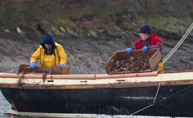
The appearance of UK rivers can be misleading when it comes to their actual condition. During my recent visit to the Fal River in south-west England, I was captivated by its breathtaking beauty, assuming it to be pristine. However, the reality is quite different. Despite being located within the Cornwall Area of Outstanding Natural Beauty and being the home of the Fal oyster, a protected designation of origin food, it has earned the unfortunate title of “the most polluted river in England.”
In a comprehensive analysis conducted by the Independent newspaper, Environment Agency (EA) data on sewage spills in England revealed an alarming reality about the Fal River. Disturbingly, in 2021 alone, the river was subjected to the flow of raw sewage for a staggering duration of nearly 7500 hours, equivalent to over 10 solid months. This contamination resulted from the discharge of untreated wastewater through 103 storm overflows that directly released into the river.
The revelation may appear shocking, but these occurrences are inherent to the wastewater treatment system in the region. They occur when heavy rainfall, which is not uncommon in this area, combines with Cornwall’s century-old drainage system. The drainage system follows a combined approach, where sewage (brown water), household drainage (grey water), and rainwater are all mixed together and directed to treatment plants.
According to Tessa Wardley, a representative from The Rivers Trust, a conservation charity located in Callington, Cornwall, the current wastewater system is deemed archaic. Tessa highlights that the system has not undergone sufficient updates and upgrades to meet modern requirements. As it stands, sewage exits residential properties through one pipeline, which eventually merges with the pipeline that collects road drainage water.
Following a storm, the combined influx of rainwater and sewage poses a significant challenge for the treatment plants, increasing the risk of contaminated water flowing back into residential and commercial properties. To mitigate this risk, the local water company, South West Water, has authorization to activate emergency overflow pipes, redirecting the surplus directly into the Fal River. Tessa Wardley emphasizes the magnitude of this issue, acknowledging it as a substantial problem.
A helpful approach to assess the potential condition of a nearby river is to determine whether the local sewage system is combined with rainwater runoff or operates separately. Typically, urban areas tend to have combined sewage and rainwater systems, while rural areas tend to keep them separate. However, it is important to note that this is merely a general guideline, as exemplified by Cornwall’s system, which deviates from the norm.
Alternatively, the Environment Agency (EA) releases a comprehensive annual dataset on storm overflows throughout England, with similar resources available for the other nations of the UK. While it may require some effort to delve into the data, detailed information is available. Through my own investigation, I discovered that an overflow pipe in close proximity to my lodging in Cornwall, which directs wastewater from a treatment plant in Mylor Bridge into the Fal River, recorded a total of 179 discharges in 2021, amounting to a cumulative duration of 145.8 hours.
However, it is essential to keep in mind that this dataset is far from comprehensive since not all overflow sites are actively monitored. Out of the 103 overflow points that discharge into the Fal River, only 67 of them collect data and provide information for analysis. Therefore, the available data may not fully capture the complete picture of the situation.

Furthermore, there are additional limitations in the available data. It solely documents the frequency and duration of discharges, without providing information on the volume of sewage-contaminated water entering the river. When visually observing the Fal River, it is evident that it is not visibly inundated with sewage, leading to strong backlash from nearby communities in response to the Independent’s report. Martin Laity, owner of Sailors Creek Shellfish and an oyster fishery in the village of Flushing, vehemently dismissed the claim that the Fal River is the most polluted in England, referring to it as “absolute rubbish” in an interview with the local newspaper, The Packet.
Laurence Couldrick from the Westcountry Rivers Trust expressed disappointment regarding the story, clarifying the situation. He stated that it is not accurate to claim that the River Fal is the most polluted in the UK, but rather it experiences the longest duration of Combined Sewage Overflow (storm drain) spills. Couldrick explained to The Packet that the monitoring conducted by water companies only provides information on the frequency and duration of spills, but crucially lacks data on the volume of sewage discharged. Therefore, while the Fal River may have the highest frequency of sewage pollution incidents among English rivers, it does not necessarily mean it is the most polluted in terms of overall contamination levels.
Status updates
For a more comprehensive understanding of the condition of rivers in the UK, it is advisable to examine both their ecological and chemical status. The assessment of all surface water bodies in the country follows the criteria outlined in the European Union’s Water Framework Directive. The Environment Agency (EA) in England, along with their counterparts in Scotland, Wales, and Northern Ireland, publishes the classifications based on these assessments. This provides valuable information regarding the ecological and chemical health of the rivers in the respective regions.
The available ratings suggest that it is highly likely that rivers in the UK are not in the best ecological condition and are contaminated with chemicals. In terms of ecological health, there are five categories ranging from high to bad. Data provided by the Joint Nature Conservation Committee, an advisory body to the UK government and devolved administrations, reveals that none of the rivers in England, Wales, and Northern Ireland fall into the highest category. Additionally, only 8 percent of Scotland’s rivers meet this top standard. These statistics highlight the concerning state of ecological health across the UK’s river systems.
In terms of chemical pollution, rivers are classified as either “good” or “failing,” based on permissible concentrations of 52 priority substances. Startlingly, according to these assessments, every single river in England is categorized as “failing.” This indicates that the allowable concentrations of the priority substances are exceeded in all of England’s rivers, highlighting a widespread issue of chemical pollution across the country’s waterways.
According to Wardley, the chemical condition of rivers is increasingly evident and significantly deteriorated. The list of pollutants and their sources is extensive, encompassing various substances such as pesticides, fertilizers, persistent chemicals like per- and polyfluoroalkyl substances (PFASs), industrial waste, microplastics, microfibers, pharmaceuticals disposed of via flushing, paint thinners, cooking oil poured down drains, detergents, car wax, and many more. This extensive range of pollutants highlights the diverse and numerous contributors to the poor chemical state of rivers.

In the absence of a chemical testing kit, the presence of pollutants may not be easily detectable. However, there are visual cues that can serve as reliable indicators of a river’s overall condition, irrespective of the specific pollutants or location. These visual clues can provide a more general assessment of the river’s health, applicable worldwide.
Stephen Addy, from CREW (Scotland’s Centre of Expertise for Waters) at the James Hutton Institute in Aberdeen, emphasizes that evaluating the physical characteristics of a river can offer valuable insights. Addy suggests considering aspects such as the river’s straightness, whether it has been canalized, its depth, and whether it is disconnected from its natural floodplain. These features are considered unnatural attributes, and their presence may indicate alterations to the river’s natural state.
According to Michael Acreman from the UK Centre for Ecology & Hydrology in Wallingford, identifying natural attributes in rivers is relatively straightforward. He explains that natural rivers exhibit complex forms with meanders and diverse habitats. They feature variations in depth, ranging from deep sections to shallower areas. Observers can also notice the presence of rocks, turbulent and sparkling water, and even hear the sound of the flowing river. These are all characteristic signs of a healthy river, which are notably absent in an unhealthy river.
Assessing water quality based solely on its appearance is challenging. Tessa Wardley explains that rivers can often appear murky, leading people to assume they are polluted and unsuitable for swimming. However, this murkiness is often caused by sediment and natural geological factors rather than pollution. To truly gauge water quality, it becomes necessary to observe and study the plants and animals that inhabit the river. Their presence and condition provide a more accurate indication of the river’s overall ecological health and water quality.
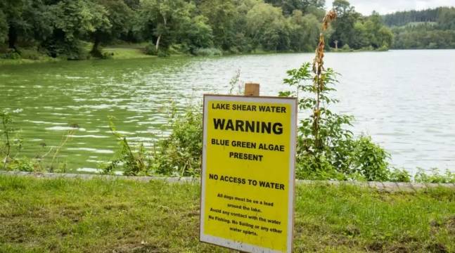
When evaluating water quality, smaller species can serve as a useful starting point. Stephen Addy explains that certain issues may indicate water quality concerns, such as excessive algae growth, particularly in the form of blue-green algae, which can be hazardous in extreme cases. Monitoring the presence and abundance of these smaller species can provide insights into potential water quality issues and the overall ecological balance of the river.
Flagship species
According to Wardley, a clear indicator of water quality issues is the presence of sewage fungus. This repulsive-looking accumulation consists of slimy, brown filamentous bacteria that flourish in water polluted with excessive nutrients. When observing this fungus coating stones and present in the river water, it is a strong indication of compromised water quality.
The presence of larger flora and fauna in rivers can serve as reliable indicators of river health. The existence of fish within the water is considered a positive sign, along with the presence of vibrant, green vegetation along the channel and riverbanks. Several “flagship species,” such as otters, freshwater pearl mussels, and dippers (a type of bird), are associated with good river health. These species depend on an ample supply of macroinvertebrates in the river and serve as indicators of good water quality, as explained by Addy. Additionally, when it comes to raw sewage, its presence is usually quite unmistakable and easily identifiable.
Wardley acknowledges that determining the condition of a river by visual inspection alone can be challenging. However, she emphasizes that there are observable signs that anyone can detect, including through the sense of smell. These indicators provide valuable clues about the state of the river and can help in assessing its overall health.


